
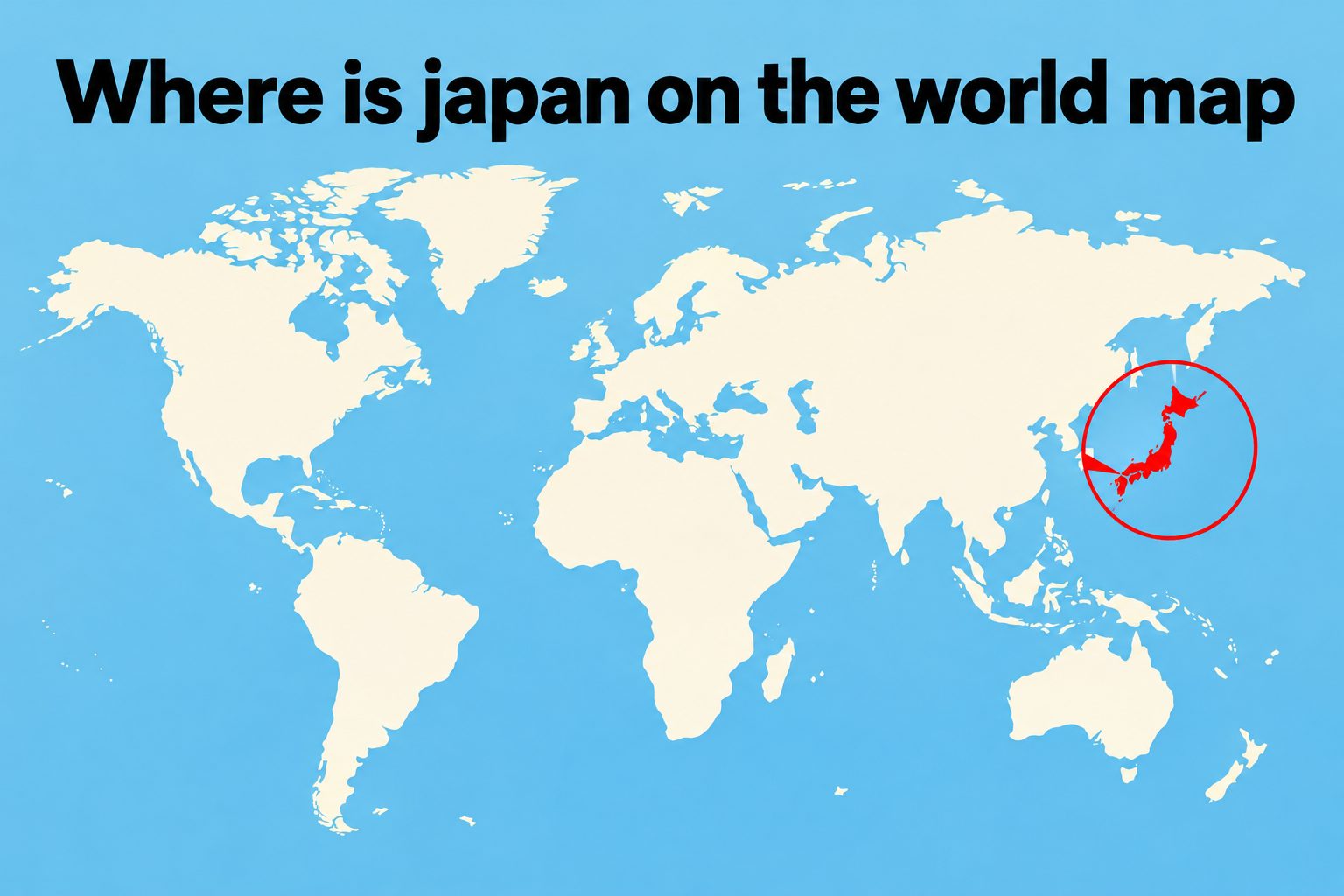
Where is Japan on the world map? Japan is an island country in East Asia, positioned in the western Pacific Ocean. It lies east of China and the Korean Peninsula, south of Russia, and north of Taiwan. Although Japan can look small on a global map, its islands stretch across a considerable distance from northeast to southwest. The country consists of four main islands and thousands of smaller ones, forming a long, curved chain near the eastern edge of the Asian continent. Knowing Japan’s location helps explain its climate, natural hazards, culture, trade connections, and historical development. It also makes it easier to plan international travel, interpret time zones, and identify nearby countries and seas. This guide explains how to find Japan on different maps, where its major islands and cities are located, why its position matters, and which common geographic mistakes to avoid.
Japan’s Exact Location On The World Map
Japan occupies a distinctive position between mainland Asia and the open Pacific Ocean. Several geographic details can help you locate it accurately.
1. Japan Is In East Asia
Japan belongs to East Asia, a region that also includes China, Mongolia, North Korea, South Korea, and Taiwan. On a standard world map, begin by finding the Asian continent. Look toward its eastern coastline, where Japan appears as a narrow chain of islands in the Pacific Ocean.
2. Japan Is In The Northern Hemisphere
The entire country is north of the equator, placing Japan in the Northern Hemisphere. This means its seasons generally follow the familiar Northern Hemisphere pattern. Summer occurs around June through August, while winter falls around December through February, although conditions vary greatly between northern and southern Japan.
3. Japan Is In The Eastern Hemisphere
Japan is also located in the Eastern Hemisphere because it lies east of the prime meridian. Its approximate geographic range extends from 24 to 46 degrees north latitude and 123 to 146 degrees east longitude when remote islands are included. These coordinates place it clearly within eastern Asia.
4. Japan Lies In The Pacific Ocean
Japan is surrounded by water and sits along the western side of the North Pacific Ocean. The Pacific lies to its east and southeast. This ocean-facing location has shaped Japan’s fishing industry, maritime trade, coastal settlements, weather patterns, and long relationship with other Pacific nations.
5. Japan Is East Of The Asian Mainland
Japan is separated from continental Asia by several bodies of water rather than sharing a land border with another country. China lies mainly to the west and southwest, while the Korean Peninsula is directly west of central Japan. Russia is located beyond Japan’s northern islands.
6. Tokyo Provides A Useful Reference Point
Tokyo, Japan’s capital, is located on the eastern side of Honshu, the country’s largest island. Its approximate coordinates are 35.7 degrees north and 139.7 degrees east. On detailed maps, finding Tokyo often makes it easier to recognize Japan and understand the location of its main population center.
Japan’s Position Relative To Nearby Countries
Japan’s location becomes clearer when it is compared with the countries and territories around it.
1. China Lies To The West
China is west and southwest of Japan across the East China Sea. Shanghai is roughly west of Japan’s southern main islands, while northeastern China lies across the sea from northern Japan. The two countries are geographically close despite being separated by international waters.
2. The Korean Peninsula Is Nearby
North Korea and South Korea occupy the Korean Peninsula west of Japan. South Korea is particularly close to the Japanese island of Kyushu. The Korea Strait separates the two countries, and the short distance has supported travel, trade, cultural exchange, and historical interaction for centuries.
3. Russia Is North Of Japan
Russia lies north and northwest of Japan. The Russian island of Sakhalin is directly north of Hokkaido, Japan’s northernmost main island. The Sea of Okhotsk separates parts of the two countries, while several smaller islands form a geographically and politically sensitive area between them.
4. Taiwan Is Southwest Of Japan
Taiwan lies southwest of Japan’s main island chain. Japan’s southwestern islands extend toward Taiwan, making the geographic distance shorter than many world maps suggest. Yonaguni, one of Japan’s westernmost inhabited islands, is much closer to Taiwan than it is to Tokyo.
5. The Philippines Lies Farther South
The Philippines is south of Japan beyond Taiwan and the Philippine Sea. Both countries form parts of the broader island systems along the western Pacific. Their locations expose them to tropical storms, active tectonic zones, and important sea routes connecting East and Southeast Asia.
6. The United States Is Across The Pacific
The continental United States is far east of Japan across the Pacific Ocean. Alaska lies to the northeast, while Hawaii is southeast of Japan. This trans-Pacific position is important for aviation, shipping, economic relations, and time-zone calculations between Japan and North America.
Japan’s Main Islands On The Map
Japan is an archipelago rather than one continuous landmass. Its four main islands contain most of its land, cities, and population.
1. Honshu Is The Largest Island
Honshu forms the long central section of Japan and is the country’s largest and most populous island. Tokyo, Yokohama, Kyoto, Osaka, Hiroshima, and many other major cities are located there. Mount Fuji also stands on Honshu, southwest of the Tokyo metropolitan area.
2. Hokkaido Is In The North
Hokkaido is Japan’s northernmost main island. It sits above Honshu and is separated from it by the Tsugaru Strait. Hokkaido is known for cold winters, heavy snow, forests, agriculture, and open landscapes. Sapporo is its largest city and principal urban center.
3. Kyushu Is In The Southwest
Kyushu is the southwesternmost of the four main islands. It is closer to South Korea and China than many parts of Honshu are. Important Kyushu cities include Fukuoka, Nagasaki, Kumamoto, and Kagoshima. The island is noted for active volcanoes and geothermal features.
4. Shikoku Is South Of Honshu
Shikoku is the smallest of Japan’s four main islands. It lies south of western Honshu and east of Kyushu, beside the Seto Inland Sea. Bridges connect it to Honshu. Its mountainous landscape, pilgrimage routes, agriculture, and relatively quiet cities give it a distinct identity.
5. Okinawa Extends Toward Taiwan
Okinawa refers both to a prefecture and to its best-known island. It belongs to the Ryukyu island chain, which stretches southwest from Kyushu toward Taiwan. On many small world maps, these islands are difficult to see, but they form an important part of Japanese territory.
6. Thousands Of Smaller Islands Complete Japan
Beyond the four main islands, Japan includes thousands of smaller islands. Some are inhabited, while many are remote or uninhabited. These include islands in the Seto Inland Sea, the Izu and Ogasawara groups, and distant territories extending Japan’s maritime reach into the Pacific.
Key Geographic Features Around Japan
The seas, straits, and physical features around Japan provide useful reference points and influence everyday life throughout the country.
- Pacific Ocean: The Pacific borders Japan’s eastern coastline and connects the country with major international sea routes.
- Sea Of Japan: This body of water lies between Japan, the Korean Peninsula, and the Russian mainland.
- East China Sea: Located southwest of Japan, it separates the country’s southern islands from China.
- Sea Of Okhotsk: This cold northern sea borders Hokkaido and Russia and is known for seasonal drift ice.
- Seto Inland Sea: This sheltered waterway lies between Honshu, Shikoku, and Kyushu and contains numerous small islands.
- Japanese Mountains: Mountain ranges cover much of the country, concentrating many communities and transport routes along coastal plains.
How To Find Japan On Any Map
A simple search process can help you identify Japan quickly, even when a map has limited labels or detail.
- Find Asia: Locate the world’s largest continent, usually shown in the upper-right or central-right part of a standard world map.
- Move Toward East Asia: Look for China near the continent’s eastern coastline.
- Find The Korean Peninsula: Identify the narrow peninsula extending south from the Asian mainland.
- Look Directly East: Move across the water from Korea until you reach a curved group of islands.
- Check The Island Shape: Confirm that the country forms a long chain running from northeast to southwest.
- Identify Honshu: Look for the largest central island, which forms most of Japan’s recognizable outline.
- Find Tokyo If Labeled: Tokyo should appear on the eastern coast of central Honshu.
- Confirm The Pacific: The large ocean immediately east of the islands should be the Pacific Ocean.
Why Japan’s Location Matters
Japan’s position is more than a point on a map. It influences the country’s environment, economy, society, and connections with the wider world.
Japan lies along the Pacific Ring of Fire, an active zone where tectonic plates meet. This setting explains why the country experiences earthquakes, volcanic activity, and occasional tsunamis. It also accounts for Japan’s mountainous landscape and numerous hot springs.
The surrounding seas give Japan access to valuable fishing grounds and international shipping lanes. Because the country imports many energy resources and raw materials, ports and maritime transport are essential to its economy. Coastal cities developed as major commercial and industrial centers.
The islands extend across several climate zones. Hokkaido experiences snowy winters, central Japan has four distinct seasons, and Okinawa has a subtropical climate. Ocean currents, seasonal winds, elevation, and latitude create significant regional differences within a relatively narrow country.
Japan’s separation from the mainland encouraged the development of distinctive traditions while never completely preventing outside influence. Ideas, technologies, religions, writing systems, and goods crossed the surrounding seas, especially through Korea and China, and were adapted within Japanese society.
Its modern location between Asian markets and the Pacific has made Japan a major center for trade, aviation, technology, and diplomacy. Reading its map position therefore helps explain both physical geography and Japan’s continuing importance in regional and global affairs.
Examples Of Japan’s Location In Daily Life
Several practical situations show why knowing Japan’s position on the world map is useful.
1. Planning An International Flight
Travelers use Japan’s location to estimate routes and journey times. Flights from nearby East Asian cities are generally much shorter than flights from Europe or North America. Tokyo, Osaka, and other gateways also serve as convenient connections between Asian and Pacific destinations.
2. Calculating Time Differences
Japan uses Japan Standard Time throughout the country. Its eastern location means the Japanese business day often begins before working hours in Europe and the Americas. Knowing where Japan sits relative to another country makes scheduling calls, events, and online meetings easier.
3. Following Earthquake News
When an earthquake is reported near Japan, a map helps readers identify the affected island, coastline, or offshore zone. This matters because an event near Hokkaido may be far from Tokyo, while an earthquake near Kyushu could affect an entirely different part of the country.
4. Reading A Weather Forecast
Japan’s long north-to-south shape explains why national forecasts can show snow in Hokkaido and warm conditions in Okinawa on the same day. Its Pacific position also places parts of the country in the path of typhoons that typically approach from southern waters.
5. Studying Asian History
A regional map makes historical movement easier to follow. It shows how people, Buddhism, writing, artistic traditions, and political ideas reached Japan from continental Asia. It also reveals why maritime travel and strategic straits played important roles in Japan’s international relationships.
6. Comparing Travel Regions
Visitors can use the island layout to build a realistic itinerary. Tokyo and Kyoto are both on Honshu, but Sapporo is in Hokkaido and Fukuoka is in Kyushu. Recognizing these distances prevents travelers from treating widely separated destinations as neighboring cities.
Common Japan Map Mistakes To Avoid
Small map scales and unfamiliar regional geography can lead to several common misconceptions about Japan.
1. Treating Japan As A Single Island
Japan is often described casually as an island, but it is an archipelago containing four main islands and many smaller ones. Referring to the entire country as one island hides important regional differences and can create confusion when discussing travel, climate, cities, or local culture.
2. Placing Japan In Southeast Asia
Japan is part of East Asia, not Southeast Asia. Countries such as Thailand, Vietnam, Malaysia, Indonesia, and the Philippines are generally grouped within Southeast Asia. Japan lies farther north, directly east of China and the Korean Peninsula in the western Pacific.
3. Assuming Japan Shares Land Borders
Japan has no land borders because all its territory consists of islands. Its closest international neighbors are reached across seas and straits. Map labels placed close together may make borders seem connected, so readers should check coastlines and surrounding water carefully.
4. Confusing Tokyo With The Whole Country
Tokyo is Japan’s capital and largest metropolitan center, but it represents only one part of the country. Japan extends far north and southwest of Tokyo. Major regions such as Hokkaido, Kansai, Kyushu, Shikoku, and Okinawa have their own geography and character.
5. Underestimating Japan’s Length
Because Japan is narrow, it can look very small on a world map. However, its island chain stretches for thousands of kilometers when remote islands are included. Traveling from northern Hokkaido to southern Okinawa covers a substantial distance and crosses different climate zones.
6. Relying On A Distorted Map Projection
World map projections can change the apparent size and distance of countries, especially toward the poles. Japan may seem closer to or farther from certain places depending on the projection. A globe or regional map gives a more balanced view of relative location.
Best Practices For Reading A Japan Map
Using the right map and reference points produces a more accurate picture of Japan’s geography.
1. Begin With A Regional View
A map of East Asia usually shows Japan more clearly than a full world map. It provides enough context to compare Japan with China, Korea, Russia, and Taiwan while preserving the shapes of the main islands, nearby seas, and important regional distances.
2. Check The Map Orientation
Most maps place north at the top, but not all maps follow this convention. Always check the compass indicator before deciding which country lies east, west, north, or south of Japan. This simple habit prevents basic directional errors.
3. Use Latitude And Longitude
Coordinate lines provide a precise way to confirm location. Japan occupies middle latitudes in the Northern Hemisphere and longitudes well east of the prime meridian. Coordinates are especially useful when identifying remote islands or comparing Japanese cities with places in other countries.
4. Compare More Than One Scale
Start with a world map to see Japan’s global position, then use a regional map for neighboring countries and a national map for islands, cities, and prefectures. Changing scale reveals details that cannot fit clearly on a single map.
5. Identify Water As Well As Land
The Pacific Ocean, Sea of Japan, East China Sea, and Sea of Okhotsk are valuable location clues. Recognizing these waters helps explain Japan’s boundaries and relationships with nearby countries more accurately than focusing on land shapes alone.
6. Review The Map Legend
Colors and symbols can represent political borders, elevation, population, roads, climate, or other features. Read the legend before interpreting them. A physical map, for example, uses color differently from a political map and answers a different set of questions.
Practical Uses Of Japan’s Map Location
Knowing where Japan is located supports education, travel, communication, and informed decision-making.
1. Classroom Geography
Students can use Japan as a clear example of an archipelago, an East Asian country, and a nation affected by plate tectonics. Locating it also strengthens knowledge of hemispheres, coordinates, oceans, regional groupings, neighboring countries, and map scale.
2. Travel Planning
A map helps travelers group destinations by island and region, compare transport options, and avoid unrealistic schedules. It also clarifies why domestic flights may be practical for Okinawa or Hokkaido while high-speed rail works well between many cities on Honshu.
3. Business Communication
International businesses need geographic awareness when arranging meetings, deliveries, and market activity. Japan’s time zone and Pacific location affect communication schedules and shipping routes. Regional knowledge also helps teams discuss ports, manufacturing centers, and customer markets more precisely.
4. Weather And Disaster Awareness
Maps allow residents and international observers to follow typhoons, earthquakes, volcanic alerts, and tsunami information. The exact location matters because risk differs by coastline, island, and region. National headlines do not always mean that every part of Japan is affected.
5. Cultural Study
Geography adds context to Japanese food, architecture, agriculture, festivals, and regional identities. Coastal communities developed differently from mountain settlements, while northern and southern climates support different crops. Mapping these areas makes cultural differences easier to interpret without oversimplifying Japan.
6. News And International Relations
Japan’s position helps readers follow discussions about maritime trade, regional security, territorial issues, and cooperation in East Asia. A map shows the proximity of Japan to Korea, China, Russia, and Taiwan and explains why surrounding seas carry strategic importance.
Frequently Asked Questions
1. Where Is Japan Located In Asia?
Japan is located in East Asia, off the eastern coast of the Asian mainland. It lies east of China and North and South Korea, south of Russia, and northeast of Taiwan. Its islands extend through the western Pacific Ocean from northeast to southwest.
2. Is Japan Part Of China?
No, Japan is an independent country and is not part of China. The two nations are separated mainly by the East China Sea. They have distinct governments, languages, histories, and territories, although centuries of trade and cultural exchange have connected them.
3. What Continent Is Japan In?
Japan is generally classified as part of Asia, specifically East Asia. Geographically, it is an island country located off the Asian continent rather than on the continental mainland. Its regional neighbors include China, the Korean Peninsula, Russia, and Taiwan.
4. What Ocean Surrounds Japan?
The Pacific Ocean lies east and southeast of Japan. Other surrounding waters include the Sea of Japan to the west, the East China Sea to the southwest, the Sea of Okhotsk to the north, and the Philippine Sea toward the south.
5. How Far Is Japan From The Equator?
Japan lies well north of the equator. Its territory spans approximately 24 to 46 degrees north latitude when the main and remote islands are considered. This broad range contributes to climates that vary from cold and snowy in the north to subtropical in the south.
6. Which Country Is Closest To Japan?
Japan has several close neighbors, and the answer depends on the islands and territories being measured. Russia and South Korea are very close to northern and western Japan, while Taiwan is near Japan’s southwestern islands. Japan shares no land boundary with any country.
Conclusion
Japan is an East Asian island country in the western Pacific Ocean. It sits east of China and the Korean Peninsula, south of Russia, and northeast of Taiwan. Its four main islands are Honshu, Hokkaido, Kyushu, and Shikoku, while Okinawa and thousands of smaller islands extend its territory farther across the sea.
Finding Japan becomes simple when you first locate Asia, move to its eastern coast, identify Korea, and look across the water for a long, curved island chain. This location explains much about Japan’s climate, natural hazards, transportation, culture, trade, and relationships with neighboring countries.
Discussion