
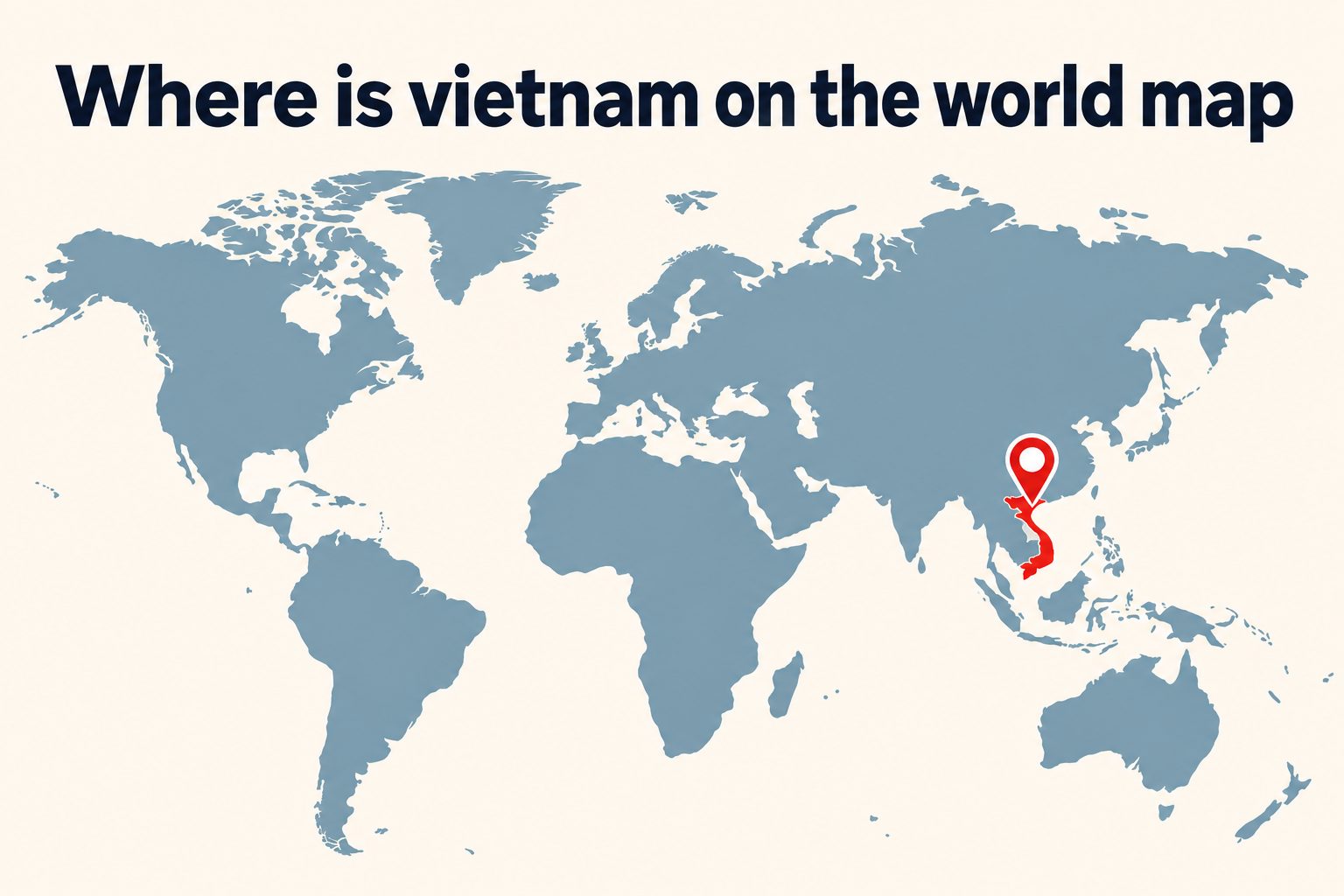
Vietnam is a long, narrow country in Southeast Asia, but its distinctive shape and coastal position make it relatively easy to identify once you know what to look for. If you are wondering where is Vietnam on the world map, look along the eastern edge of mainland Southeast Asia, beside the South China Sea. China lies to the north, while Laos and Cambodia border Vietnam to the west. The country stretches southward for more than 1,600 kilometers before reaching the Gulf of Thailand. Its location has influenced its climate, history, trade, food, and cultural connections with neighboring countries. It also places Vietnam near major Asian destinations such as Thailand, Singapore, Malaysia, and the Philippines. This guide explains Vietnam’s exact position, borders, regions, nearby seas, major cities, time zone, and importance. You will also learn how to find the country quickly on different maps and avoid common geographical mistakes.
Vietnam’s Location On The World Map
Vietnam is located in the Northern and Eastern Hemispheres. It forms part of mainland Southeast Asia, a region positioned between South Asia, East Asia, and the islands of maritime Southeast Asia.
1. Vietnam’s Continent
Vietnam is in Asia, the world’s largest continent. More specifically, it belongs to Southeast Asia. This subregion includes mainland countries such as Thailand, Cambodia, Laos, and Myanmar, along with island or partly island nations including Indonesia, the Philippines, Singapore, Brunei, Malaysia, and Timor-Leste.
2. Vietnam’s Position In Southeast Asia
On a regional map, Vietnam appears on the eastern side of the Indochinese Peninsula. It follows the coast from the Chinese border in the north to the Gulf of Thailand in the southwest. Its position gives it extensive access to important regional sea routes.
3. Vietnam’s Hemispheres
The entire country lies north of the Equator, placing it in the Northern Hemisphere. It is also east of the Prime Meridian, so it belongs to the Eastern Hemisphere. These basic reference points make Vietnam easier to place on a globe or world map.
4. Vietnam’s Approximate Coordinates
Vietnam extends approximately from 8 to 23 degrees north latitude and from 102 to 110 degrees east longitude. Hanoi, the capital, is near 21 degrees north and 106 degrees east. These coordinates place northern Vietnam within the tropical zone but close to the Tropic of Cancer.
5. Vietnam’s Distinctive Shape
Vietnam is often described as S-shaped because it curves along the eastern side of mainland Southeast Asia. The country is broad in the north and south but extremely narrow in parts of the center. This unusual outline is a helpful visual clue.
6. Vietnam’s Coastal Position
Vietnam faces the South China Sea along most of its eastern and southern sides. In Vietnam, this body of water is commonly called the East Sea. The country’s long coastline supports fishing, shipping, tourism, ports, and connections with other Asian markets.
7. Vietnam’s Distance From The Equator
Southern Vietnam is relatively close to the Equator, while northern Vietnam lies much farther north. This considerable north-to-south distance produces noticeable differences in seasons and temperatures. The south remains warm throughout the year, whereas the north experiences cooler winters.
Countries And Seas Bordering Vietnam
Vietnam has land borders with three countries and maritime surroundings that connect it to the wider Asia-Pacific region.
China borders Vietnam to the north. The land boundary passes through mountainous landscapes and links the two countries through several important trade crossings.
Laos lies along much of Vietnam’s western border. The Annamite Range creates a natural geographical divide between the two countries in many areas.
Cambodia borders southwestern Vietnam. This boundary is closer to the lowlands surrounding the Mekong River and the fertile Mekong Delta.
The South China Sea extends along Vietnam’s east and southeast. It separates Vietnam from the Philippines and the island of Borneo.
The Gulf of Tonkin lies between northern Vietnam and southern China. Hanoi is inland from this gulf, while the port city of Hai Phong sits closer to its coast.
The Gulf of Thailand touches Vietnam’s far southwest. Phu Quoc Island, one of the country’s best-known destinations, is situated in this gulf near Cambodia.
Vietnam’s Place In Mainland Southeast Asia
Vietnam belongs to a mainland area historically called Indochina. Its position helps explain its close geographical and cultural relationships with surrounding nations.
1. Vietnam Compared With Thailand
Vietnam and Thailand occupy similar latitudes, but they do not share a border. Laos and Cambodia lie between much of the two countries. Vietnam faces the South China Sea, whereas Thailand’s coastlines open mainly toward the Gulf of Thailand and the Andaman Sea.
2. Vietnam Compared With Cambodia
Cambodia is west of southern Vietnam and shares an extensive border with it. Ho Chi Minh City is relatively close to Cambodia compared with northern Vietnamese cities. The Mekong River connects both countries before spreading through Vietnam’s delta and reaching the sea.
3. Vietnam Compared With Laos
Laos lies directly west of Vietnam and is landlocked. Vietnam’s coastline therefore provides important maritime access within the region. Mountain ranges dominate much of their shared frontier, so road journeys between the two countries can involve winding routes and long travel times.
4. Vietnam Compared With China
China lies north of Vietnam and is much larger in both area and population. Vietnam’s northern provinces meet China’s Guangxi and Yunnan regions. Historical trade, migration, cultural exchange, and conflict have all been influenced by this shared geographical boundary.
5. Vietnam Compared With The Philippines
The Philippines is east of Vietnam across the South China Sea. Although the two countries have no land border, they are maritime neighbors. Their positions on opposite sides of the sea are important for shipping, fishing, weather systems, and regional relations.
6. Vietnam Compared With Singapore
Singapore is southwest of Vietnam near the southern end of the Malay Peninsula. It is not directly beside Vietnam, but flights between the two countries are relatively short. Both occupy strategically important positions along major Asian trade and transportation routes.
7. Vietnam Compared With Indonesia
Indonesia lies south of mainland Southeast Asia and consists of thousands of islands. Parts of Indonesia are located south and southeast of Vietnam across regional waters. Unlike long and narrow Vietnam, Indonesia stretches broadly across the Equator between the Indian and Pacific Oceans.
How To Find Vietnam On A Map
A simple search process can help you locate Vietnam quickly, even on a crowded world map.
1. Locate Asia on the eastern side of a standard world map.
2. Find China, one of the largest and most recognizable countries in East Asia.
3. Move south from China toward the smaller countries of Southeast Asia.
4. Look for the Indochinese Peninsula between India and the South China Sea.
5. Identify the long, narrow country running down the peninsula’s eastern coast.
6. Confirm that Laos and Cambodia are immediately to its west.
7. Check for the Gulf of Tonkin near northern Vietnam and the South China Sea to the east.
8. Look for Hanoi in the north and Ho Chi Minh City in the south if cities are displayed.
Vietnam’s Main Geographic Regions
Vietnam’s great length creates several distinct regions. Each one has different landscapes, cities, weather patterns, and economic activities.
1. Northern Vietnam
Northern Vietnam includes Hanoi, the Red River Delta, mountain provinces, and the coast around Ha Long Bay. The region borders China and Laos. It has four more noticeable seasons than southern Vietnam, including a cooler winter from approximately December through February.
2. The Red River Delta
The Red River Delta surrounds Hanoi and extends eastward toward the Gulf of Tonkin. It is densely populated and agriculturally productive. Flat land, rivers, transport networks, and proximity to major cities have made it one of Vietnam’s most important economic and cultural areas.
3. Northern Highlands
Vietnam’s northern highlands contain steep mountains, deep valleys, and terraced farmland. Fansipan, the country’s highest mountain, is located in this broad region. Communities near Ha Giang, Lao Cai, and Cao Bang live close to dramatic landscapes and parts of the Chinese border.
4. Central Vietnam
Central Vietnam forms the narrow middle of the country. In some places, the distance between Laos and the sea is surprisingly small. This region includes historic Hue, coastal Da Nang, Hoi An, mountain passes, beaches, and sections of the Annamite Range.
5. Central Highlands
The Central Highlands lie inland, mostly west of the central coastal plains. This elevated region is known for forests, waterfalls, fertile volcanic soil, and coffee production. It sits near the borders with Laos and Cambodia and has a strong presence of ethnic minority cultures.
6. Southern Vietnam
Southern Vietnam includes Ho Chi Minh City, surrounding industrial provinces, and the lowlands extending toward the Mekong Delta. The region has a tropical climate with wet and dry seasons rather than a cold winter. It is an important center for commerce and transportation.
7. The Mekong Delta
The Mekong Delta occupies Vietnam’s far south and southwest. Here, the Mekong divides into many channels before flowing into the sea. Fertile soils and abundant water support rice fields, fruit farms, fishing communities, floating markets, and a complex network of settlements.
Major Vietnamese Cities On The Map
Cities provide useful reference points when reading a detailed map of Vietnam. They also reveal how population and economic activity are distributed along the country’s length.
Hanoi is Vietnam’s capital and is located in the north, inland from the Gulf of Tonkin. It serves as the country’s political center and has a long history reflected in its old neighborhoods, lakes, temples, and colonial-era buildings.
Hai Phong is east of Hanoi and close to the northern coast. It is a major port city and an important gateway for industry, shipping, and travel to nearby coastal attractions.
Hue sits in central Vietnam near the coast. As a former imperial capital, it is closely associated with royal monuments, historic architecture, and the Perfume River.
Da Nang is farther south along the central coast. Its position roughly between Hanoi and Ho Chi Minh City makes it a major regional transportation hub with road, rail, air, and sea connections.
Hoi An is south of Da Nang and close to the coast. It is smaller than Vietnam’s main metropolitan areas but widely recognized for its preserved historic center and trading-port heritage.
Nha Trang is on the south-central coast. Its bay, beaches, islands, and warm climate make it one of the country’s prominent seaside destinations.
Ho Chi Minh City is in southern Vietnam, north of the Mekong Delta. Formerly known as Saigon, it is the country’s largest city and a leading center for business, finance, transportation, and international travel.
Why Vietnam’s Location Is Important
Vietnam’s geographical position provides economic, cultural, environmental, and strategic benefits while also creating certain challenges.
The long coastline supports commercial ports, fishing grounds, beach tourism, and international shipping. It gives Vietnam direct access to maritime routes linking Northeast Asia with Southeast Asia and markets farther west.
Vietnam’s borders connect it with China, Laos, and Cambodia. Roads, railways, and border crossings allow goods and travelers to move between coastal Vietnam and inland areas of mainland Southeast Asia.
The country’s varied latitude supports diverse agricultural products. Northern areas can grow crops suited to cooler conditions, while the tropical south supports rice, fruit, coconuts, and other warm-weather produce.
Vietnam sits near several large Asian economies. This proximity helps manufacturers participate in regional supply chains and reach major markets through land routes, seaports, and international airports.
Its position also exposes it to tropical storms forming over the western Pacific and South China Sea. Central and northern coastal areas can experience typhoons, intense rain, flooding, and landslides.
The shape of the country creates long domestic travel distances. Hanoi and Ho Chi Minh City are separated by more than 1,100 kilometers in a straight line, and overland routes are longer.
How Location Shapes Vietnam’s Climate
Vietnam is tropical overall, but its climate is not uniform. Latitude, elevation, monsoon winds, mountains, and proximity to the sea produce strong regional variations.
Northern Vietnam has hot, humid summers and relatively cool winters. Mountain districts can become cold, and temperatures at high elevations occasionally approach freezing.
Central Vietnam has a complicated climate because mountains affect seasonal winds and rainfall. Some areas experience heavy rain and storms later in the year than northern or southern destinations.
Southern Vietnam remains warm throughout the year. Its weather is generally divided into a dry season and a rainy season, although short tropical downpours can occur without lasting all day.
The South China Sea contributes moisture and influences storms. Coastal areas often receive cooling breezes, but they are also exposed to typhoons, erosion, storm surges, and saltwater intrusion.
Elevation makes a major difference. Places such as Da Lat have milder temperatures than nearby lowlands because they sit high above sea level, despite being located in southern Vietnam.
Climate patterns matter when planning travel. Conditions in Hanoi, Da Nang, and Ho Chi Minh City can be very different during the same month, so travelers should check regional weather rather than relying on one national forecast.
Vietnam’s Location And International Travel
Knowing Vietnam’s place on the map helps travelers plan routes, estimate journey times, and combine the country with nearby destinations.
1. Travel From East Asia
Vietnam is easily reached from major East Asian cities by air. Travelers coming from China, Japan, South Korea, Taiwan, or Hong Kong often arrive through Hanoi, Ho Chi Minh City, or Da Nang. Northern Vietnam is geographically closest to southern China.
2. Travel From Thailand
Flights connect Bangkok with several Vietnamese cities. Overland travel is also possible, but it normally requires crossing Laos or Cambodia because Thailand and Vietnam do not share a border. This distinction is important when estimating travel times from a regional map.
3. Travel From Cambodia
Cambodia and southern Vietnam can be combined conveniently because they share a land border. Travelers commonly move between Phnom Penh and Ho Chi Minh City by road. Some routes also connect communities through waterways associated with the Mekong system.
4. Travel From Laos
Several land crossings connect Laos and Vietnam, but mountains can make journeys slow. Distances that appear short on a flat map may require many hours by road. Travelers should consider terrain and road conditions, not just straight-line distance.
5. Travel From Singapore And Malaysia
Singapore and Malaysia lie southwest of Vietnam and have regular air connections with its main cities. Flights are usually the most practical option because the countries are separated by other territories and stretches of sea.
6. Domestic North To South Travel
Vietnam’s narrow shape encourages north-to-south itineraries. Flights save time, while trains and buses offer closer views of the landscape. A complete journey may include Hanoi, central coastal cities, Ho Chi Minh City, and the Mekong Delta.
Common Vietnam Map Mistakes To Avoid
Several misconceptions can lead readers to place Vietnam incorrectly or misjudge distances.
1. Confusing Vietnam With Thailand
Vietnam and Thailand are both in mainland Southeast Asia, but they are not neighboring countries. Vietnam occupies the peninsula’s eastern coast, while Thailand lies farther west. Laos and Cambodia separate their territories in most areas.
2. Placing Vietnam In East Asia
Vietnam has historical and cultural connections with East Asia, but standard geographical classifications place it in Southeast Asia. It sits directly south of China and forms part of the Indochinese Peninsula.
3. Assuming Vietnam Is An Island
Vietnam has numerous islands, but its main territory is part of continental Asia. It shares long land borders with China, Laos, and Cambodia. The extensive coastline can make it appear island-like on simplified maps.
4. Underestimating The Country’s Length
Vietnam looks thin on many maps, yet it stretches more than 1,600 kilometers from north to south. A journey between Hanoi and Ho Chi Minh City is therefore much longer than travel between nearby provinces.
5. Assuming One Climate Covers Vietnam
The country’s length, mountains, and seasonal winds create several climate zones. Cool conditions in the northern highlands can occur while southern beaches remain hot. Regional forecasts are more useful than broad national descriptions.
6. Confusing Hanoi With Ho Chi Minh City
Hanoi is the national capital and lies in northern Vietnam. Ho Chi Minh City is the largest city and is in the south. Their separate locations explain many differences in weather, history, architecture, and travel routes.
7. Ignoring Mountain Terrain
A map may show Laos or China close to a Vietnamese destination, but mountain ranges can complicate border travel. Travel time depends on available crossings, roads, transport schedules, and local conditions rather than distance alone.
Best Practices For Reading A Vietnam Map
Maps are most useful when you know their scale, purpose, labels, and limitations.
1. Begin With The Regional View
Start with a map of Southeast Asia before studying provinces or streets. This wider perspective shows Vietnam’s relationship with China, Laos, Cambodia, Thailand, the Philippines, and regional seas. Once oriented, move to a more detailed national map.
2. Use The Coastline As A Guide
Vietnam’s long eastern coastline is its easiest visual feature to recognize. Trace the coast south from China and look for the country’s curved outline. This approach works even when national labels are small or difficult to read.
3. Check The Map Scale
Distances in Vietnam are easy to underestimate because the country is narrow. Always examine the scale before judging how close two destinations are. A small gap on a national map may represent hundreds of kilometers and many hours of travel.
4. Notice Mountains And Rivers
Physical features explain why roads, settlements, and borders follow certain routes. The Annamite Range affects western Vietnam, while the Red and Mekong river systems shape major lowland regions. A physical map often provides more context than a political map.
5. Compare Several Map Types
Political maps show borders and cities, physical maps show terrain, and transport maps emphasize roads or railway lines. Weather and elevation maps answer different questions. Comparing them gives a more accurate picture than depending on one simplified map.
6. Confirm Historical Names
Some locations may appear under older names in books or historical documents. Ho Chi Minh City was widely known as Saigon, while older spellings may be used for other places. Confirming current names helps prevent confusion when comparing sources.
7. Allow For Map Distortion
Flat world maps distort size, distance, or shape because Earth is spherical. Vietnam may look different depending on the map projection. A globe or detailed regional map gives a better sense of its orientation and true relationship with nearby countries.
Practical Uses Of Vietnam’s Map Location
Vietnam’s position is useful knowledge for travel, education, trade, culture, and environmental planning.
1. Planning A Southeast Asia Trip
Travelers can build a logical route by seeing which countries border Vietnam. Cambodia and Laos suit overland combinations, while Thailand, Singapore, Malaysia, and the Philippines are commonly reached by air. Geography helps reduce unnecessary backtracking.
2. Studying Asian Geography
Vietnam is a useful reference point for learning mainland Southeast Asia. From Vietnam, students can identify China to the north, Laos and Cambodia to the west, and maritime Southeast Asia across the surrounding seas.
3. Comparing Regional Cultures
Vietnam’s position between East and Southeast Asia helps explain its varied influences. Geography provides context for language, religion, architecture, cuisine, trade, and historical relationships without suggesting that neighboring cultures are identical.
4. Planning Business Logistics
Companies use location data to assess ports, border crossings, manufacturing zones, airports, and delivery routes. Northern Vietnam is close to southern China, while southern Vietnam connects naturally with Cambodia, the Mekong region, and major maritime routes.
5. Following Weather Events
Knowing the location of Vietnam helps readers interpret typhoon paths, monsoon patterns, floods, and seasonal rainfall. Coastal exposure and mountainous terrain influence which areas face the greatest risks during particular weather events.
6. Learning About Agriculture
Maps clarify why rice is important in the Red River and Mekong deltas, why coffee thrives in the Central Highlands, and why fishing supports coastal communities. Terrain and climate are closely connected to local food production.
7. Exploring Vietnamese History
Location influenced migration, warfare, colonial trade, regional diplomacy, and the development of historic ports. Studying a map alongside historical events makes movements between northern, central, and southern Vietnam easier to follow.
Frequently Asked Questions
1. Where Exactly Is Vietnam Located?
Vietnam is on the eastern side of mainland Southeast Asia. China borders it to the north, Laos and Cambodia lie to the west, and the South China Sea is to the east and south. The country extends from near the Tropic of Cancer toward the Gulf of Thailand.
2. Is Vietnam In Asia Or Southeast Asia?
Both descriptions are correct. Asia is the continent, while Southeast Asia is the subregion. Vietnam is one of the mainland Southeast Asian countries and forms part of the Indochinese Peninsula with Cambodia, Laos, Myanmar, Thailand, and Peninsular Malaysia.
3. What Countries Share A Border With Vietnam?
Vietnam shares land borders with China, Laos, and Cambodia. China is north of Vietnam, while Laos runs along much of the western side. Cambodia borders the southwest. Thailand is nearby but does not share a direct border with Vietnam.
4. Is Vietnam Close To Thailand?
Vietnam is relatively close to Thailand within Southeast Asia, but the two countries do not touch. Laos and Cambodia lie between them. Direct flights are usually the fastest option, while overland journeys must pass through one of those neighboring countries.
5. What Is The Capital Of Vietnam?
Hanoi is the capital of Vietnam. It is located in the northern part of the country near the Red River and inland from the Gulf of Tonkin. Ho Chi Minh City, in southern Vietnam, is larger but is not the national capital.
6. Is Vietnam North Or South Of The Equator?
Vietnam is entirely north of the Equator, so it lies in the Northern Hemisphere. Its southernmost areas are closer to the Equator than its northern provinces. This broad latitude range contributes to regional differences in seasons, temperatures, and rainfall.
7. Which Sea Is Next To Vietnam?
The South China Sea lies along most of Vietnam’s eastern and southern coast. Vietnamese usage often calls it the East Sea. The Gulf of Tonkin is in the north, while the Gulf of Thailand borders the country’s far southwest.
Conclusion
Vietnam is located on the eastern edge of mainland Southeast Asia, south of China and east of Laos and Cambodia. Its recognizable S-shaped territory follows a long coastline beside the South China Sea, stretching from the northern mountains to the tropical Mekong Delta. This position explains many of the country’s regional differences.
Finding Vietnam becomes simple when you first locate China and then follow the Southeast Asian coast southward. Looking at its borders, seas, cities, rivers, and mountain ranges provides a clearer picture than memorizing one point on a map. Geography offers valuable context for Vietnam’s climate, travel routes, economy, culture, and history.

Discussion